HJV
Ontario Land Surveyors
Providing professional land surveying services for:
| Land Developers | Construction Companies | Cottage Country |
| Government Agencies | Planners, Engineers & Architects | Real Estate |

Providing professional land surveying services for:
| Land Developers | Construction Companies | Cottage Country |
| Government Agencies | Planners, Engineers & Architects | Real Estate |

The name HJV carries a long-standing reputation of providing exemplary surveying services throughout Southern Ontario. This reputation is built on nearly 60 years of industry practice. We are continually evolving our methods to reflect the advancements in surveying technology while preserving our stature as a firm dedicated to accuracy and detail. From the initial research of a property, to the final registration of a plan, and everything in between; we leave no stone unturned. Combined with experienced field crews and a rigorous checking process, our surveys are delivered with absolute confidence.
The company was initially formed in 1961 by P.T. Holding O.L.S.. In 1973, Russell Jones O.L.S. joined forces with Mr. Holding to create Holding & Jones Limited where they maintained a successful practice until Mr. Holding’s retirement in 1990. Mr. Jones would remain president of the company until 2012 and retired in 2016.
Gary B. Vanderveen O.L.S. joined Holding & Jones Limited in 1995. In 2001, Mr. Vanderveen acquired shares in the company and the company was renamed Holding Jones Vanderveen Inc. (HJV). Mr. Vanderveen became president in 2012 upon acquiring further shares and has since remained in this position.
Thomas R. Reed O.L.S. began his employment with Holding & Jones Limited in 1989 and remained until his departure in 2008. In 2012, Mr. Reed returned to HJV a member of the AOLS and became principal. He has remained in this position since.
Throughout our course of practice we have developed strong relationships with many clients and have provided professional surveying services for Peel Region, The Regional Municipality of York, WATERFRONT Toronto, TEDCO, Canadian National Railway Company, Metrolinx, Hydro One, City of Toronto, City of Vaughan , Town of Richmond Hill, and the Ontario Realty Corporation.
We also have an extensive list of prominent private sector clients including some of the largest engineering consulting firms and land developers in Canada.

Gary B. Vanderveen O.L.S. was sworn in as a licensed Ontario Land Surveyor in 1995; the same year he joined Holding & Jones Limited. In 2001, Mr. Vanderveen acquired shares in the company and the company was renamed Holding Jones Vanderveen Inc. (HJV). Mr. Vanderveen became president in 2012 upon acquiring further shares and has since remained in this position. |

Thomas R. Reed O.L.S. was sworn in as a licensed Ontario Land Surveyor in 2003. He began his employment with Holding & Jones Limited in 1989 and remained until his departure in 2008. In 2012, Mr. Reed returned to HJV as principal partner in the firm. He has since remained in this position. |

Stephen joined HJV as a summer student in 2011. He quickly took an interest in surveying and eventually completed his B. Eng. in Geomatics Engineering in 2017 at York University. Soon after graduating, Stephen began articling under Gary Vanderveen, O.L.S.. In January of 2020, Stephen completed his articles and was sworn in as an Ontario Land Surveyor. |
Scott Carss joined HJV in 2012 as a survey assistant for the summer. Shortly after graduating in 2013, he began full-time employment with the firm as a party chief. Scott is now the Controller for HJV and handles administrative and accounting matters. |

Rohanna Medrano has provided administrative support for the HJV team since 2022. |
Our office staff are long-standing employees of HJV and veterans of their respective roles at the company. Being well-versed in a number of software packages; including our own internally-developed calculations software; our office staff are integral to the processing of survey data. |
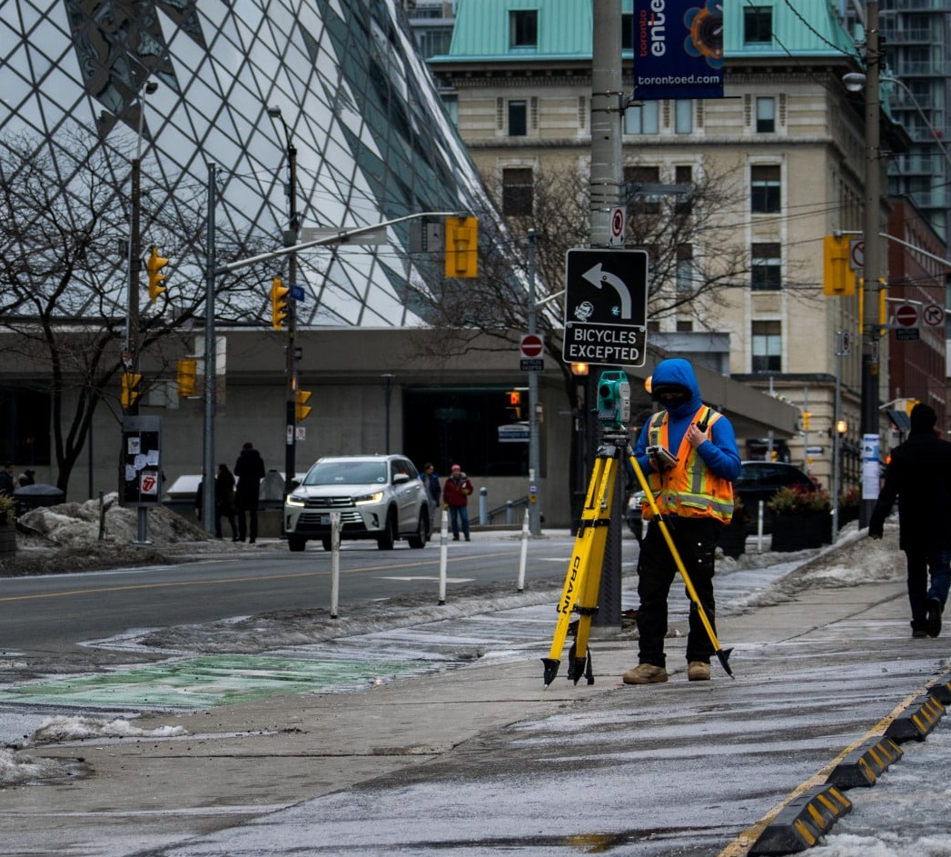
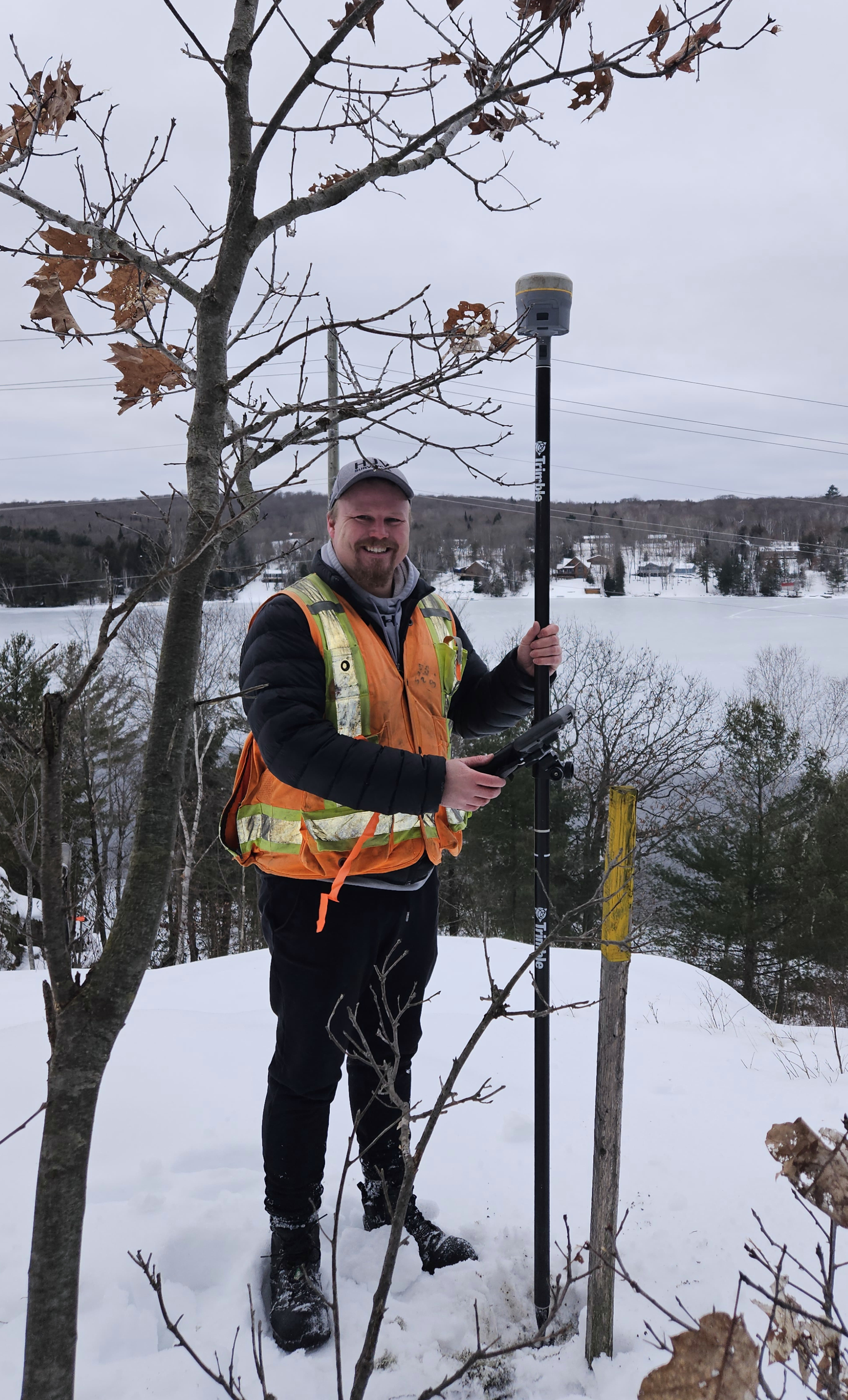
The field crews at HJV bring decades of experience into every survey we conduct. They are well-equipped with a wide range of equipment and tools; including some of the most advanced surveying instruments on the market. Striving for accuracy and detail, our field crews are the foundation of our operations at HJV. |
1700 Langstaff Road, Suite 1002, Vaughan, ON, L4K 3S3
(905) 660-4000
hjv@hjv-ols.ca
| Name | Position | |
|---|---|---|
| Gary Vanderveen, O.L.S. | President | gary@hjv-ols.ca |
| Thomas Reed, O.L.S. | Principal | tom@hjv-ols.ca |
| Stephen Kosmachuk, O.L.S. | Project Manager | stephen@hjv-ols.ca |
| Scott Carss, B.A.S. (Acc) | Controller | scott@hjv-ols.ca |
| Rohanna Medrano | Administration Accounts |
rohanna@hjv-ols.ca |
| Survey Records | hjv@hjv-ols.ca |
From a simple lot severance, to multiple lot subdivisions, to condominium projects, we have the experience and expertise to facilitate your successful development.

A registered Plan of Subdivision is a legal document which shows the exact surveyed boundaries and dimensions of lots on which houses or buildings are to be built, the location, width and names of streets, and the sites of any future schools or parks.
A registered Plan of Subdivision creates new, separate parcels of land and can be legally used for the sale of lots.
Having worked alongside some of Canada's largest developers over multiple decades, we are subdivision specialists. Whether it be the development of a few lots or a few hundred lots, our team can provide the surveying services necessary to see your subdivision through.
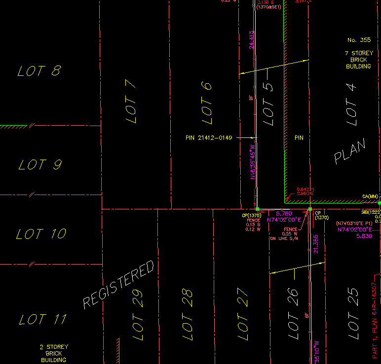
Being one of our most requested services, reference plans are graphical representations and legal descriptions of land. They show the surveyed boundary and dimensions as well as any physical or documentary evidence that could affect the title to the property. This may include the location of fences, hedges, retaining walls, overhead wires, etc. Buildings or other improvements on the property are generally not shown, unless they were used to position the boundary, or they encroach on the property. A reference plan is necessary for a severance.
Like a Plan of Subdivision, a Condominium Plan creates new parcels of land called units. Units are three-dimensional, with boundaries being the physical surfaces of the buildings themselves (this excludes vacant land condominiums). A Condominium Plan shows the exact boundaries and dimensions of each unit across all floors of the condominium.
The preparation of Condominium Plans is one of our areas of expertise. We have extensive experience providing surveying services for all types of condominiums.
Topographic surveys are plans that show the physical properties of a site. These plans may be used by engineers, architects, and planners to assist with the detailed design of a development proposal. A topographic survey may compliment a development application. It shows the physical constraints that the proponent must consider in a development application, or a detailed design of a site for development purposes.
We specialize in preparing topographic surveys, which show vertical elevations, contours, as well as physical details above and on the ground. Contours are lines on the drawing that join points that have the same elevation on the ground. Contour lines never cross each other, and the close the lines are to each other, the steeper the slope. Conversely, the further apart the lines are from each other, the flatter the slope.
Confirm the area, lot frontage, and lot width of a land parcel with a Frontage and Area Certificate.
Being one of our most requested services, a Surveyor's Real Property Report (SRPR) is prepared specifically to illustrate the location of buildings or structures relative to the boundaries of a unit of land. It also shows the location of any other physical features and registered encumbrances, such as easements, on or immediately adjacent to the property. In a real estate transaction, a current SRPR provides the purchaser, the seller, the lending institution, the municipality, the realtor, and all other parties to the transaction with an accurate representation of the property prior to the purchase being completed.
Errors in construction can cost a fortune in time and money. Ensure structures such as buildings, services, or roads are constructed according to design with a construction layout survey. With our on-demand service, we will have a crew on-site to stake out reference points which help in guiding the construction process.
Establish and certify the lines and limits of areas which require protection. The Provincial Policy Statement, 2014, defines a natural heritage system as:
"a system made up of natural heritage features and areas, and linkages intended to provide connectivity and support natural processes which are necessary to maintain biological and geological diversity, natural functions, viable populations of indigenous species, and ecosystems. These systems can include natural heritage features and areas, federal and provincial parks and conservation reserves, other natural heritage features, lands that have been restored or have the potential to be restored to a natural state, areas that support hydrologic functions, and working landscapes that enable ecological functions to continue."
We are very familiar in working alongside conservation authorities, engineers, and environmental engineers in accurately determining these natural heritage system lines.
We offer on demand construction layout services to keep your project moving.

Errors in construction can cost a fortune in time and money. Ensure buildings are constructed according to design with a construction layout survey. With our on-demand service, we will have a crew on-site to stake out reference points which help in guiding the construction process.
Errors in construction can cost a fortune in time and money. Ensure services are constructed according to design with a construction layout survey. With our on-demand service, we will have a crew on-site to stake out reference points which help in guiding the construction process.
Ensure the grades across your construction project are built to design with a cut/fill survey. With our on-demand service, we will have a crew on-site to stake out reference points and mark them according to their relative position to the desired grade.
Our as-built surveys provide a confirmation of the positioning and grading of constructed features across a site. Any variations from what was originally designed will be identified.
Our volume surveys focus primarily on measuring current grades and breaklines across a site and referencing them against design grades to calculate an estimation of earthworks volume. This estimate is an important factor in estimating the costs and resources necessary for the required earthworks.
Confirm the location of underground utilities on your project site with an underground utility survey. Although we do not directly provide this service, we have experienced subcontractors who complete the locates so we can compile their locations accurately into our survey plans.
The position of land or any structure is subject to change. A monitoring survey can identify any deformation of a site over a period of time. We offer flexible scheduling of our crews to ensure your site can be monitored over appropriate intervals of time.
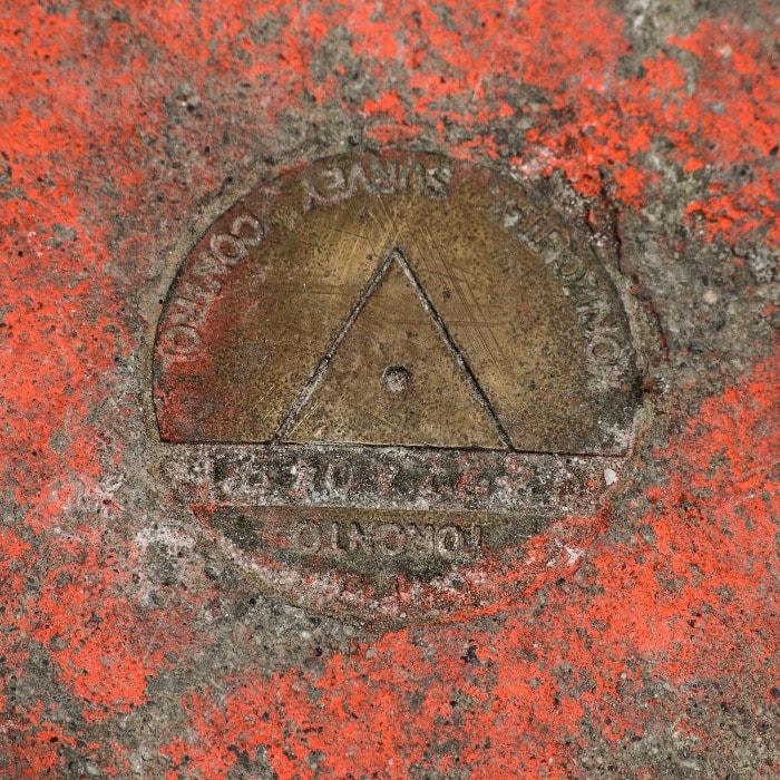
Have us establish a network of known control stations across a project site. These control stations can be established with both horizontal positions and elevations to serve as a framework for any future survey work.
Have the detail and intricacies of any building face measured and recorded with a building face survey.
Providing prompt, professional surveying services to property owners in Parry Sound, Muskoka, the Kawarthas, and Haliburton.

Being one of our most requested services, a Surveyor's Real Property Report (SRPR) is prepared specifically to illustrate the location of buildings or structures relative to the boundaries of a unit of land. It also shows the location of any other physical features and registered encumbrances, such as easements, on or immediately adjacent to the property. In a real estate transaction, a current SRPR provides the purchaser, the seller, the lending institution, the municipality, the realtor, and all other parties to the transaction with an accurate representation of the property prior to the purchase being completed.
Being one of our most requested services, reference plans are graphical representations and legal descriptions of land. They show the surveyed boundary and dimensions as well as any physical or documentary evidence that could affect the title to the property. This may include the location of fences, hedges, retaining walls, overhead wires, etc. Buildings or other improvements on the property are generally not shown, unless they were used to position the boundary, or they encroach on the property. A reference plan is necessary for a severance.
Errors in construction can cost a fortune in time and money. Ensure structures such as buildings, services, or roads are constructed according to design with a construction layout survey. With our on-demand service, we will have a crew on-site to stake out reference points which help in guiding the construction process.
Topographic surveys are plans that show the physical properties of a site. These plans may be used by engineers, architects, and planners to assist with the detailed design of a development proposal. A topographic survey may compliment a development application. It shows the physical constraints that the proponent must consider in a development application, or a detailed design of a site for development purposes.
We specialize in preparing topographic surveys, which show vertical elevations, contours, as well as physical details above and on the ground. Contours are lines on the drawing that join points that have the same elevation on the ground. Contour lines never cross each other, and the close the lines are to each other, the steeper the slope. Conversely, the further apart the lines are from each other, the flatter the slope.
HJV provides professional surveying services to all levels of government.

A route survey provides detailed information regarding the position, alignment, and grading for the design and construction of linear features such as roads, pipelines, and railways.
We are experienced in the preparation of route surveys and have worked alongside Metrolinx and other government bodies along transportation corridors.
In a real estate transaction, a current Surveyor's Real Property Report (SRPR) provides the purchaser, the seller, the lending institution, the municipality, the realtor, and all other parties to the transaction with an accurate representation of the property prior to the purchase being completed. In other words, it identifies exactly what is being purchased along with any underlying issues regarding the title.
Being one of our most requested services, reference plans are graphical representations and legal descriptions of land. They show the surveyed boundary and dimensions as well as any physical or documentary evidence that could affect the title to the property. This may include the location of fences, hedges, retaining walls, overhead wires, etc. Buildings or other improvements on the property are generally not shown, unless they were used to position the boundary, or they encroach on the property. A reference plan is necessary for a severance.
Plans of Expropriation must be prepared and signed by an Ontario Land Surveyor. The registration of a Plan of Expropriation is significant in the expropriation process as it gives the expropriating authority legal ownership of the expropriated lands. Upon registration of this plan, several time requirements are set into effect for the completion of further steps by the expropriating authority.
Topographic surveys are plans that show the physical properties of a site. These plans may be used by engineers, architects, and planners to assist with the detailed design of a development proposal. A topographic survey may compliment a development application. It shows the physical constraints that the proponent must consider in a development application, or a detailed design of a site for development purposes.
We specialize in preparing topographic surveys, which show vertical elevations, contours, as well as physical details above and on the ground. Contours are lines on the drawing that join points that have the same elevation on the ground. Contour lines never cross each other, and the close the lines are to each other, the steeper the slope. Conversely, the further apart the lines are from each other, the flatter the slope.
Being one of our most requested services, a Surveyor's Real Property Report (SRPR) is prepared specifically to illustrate the location of buildings or structures relative to the boundaries of a unit of land. It also shows the location of any other physical features and registered encumbrances, such as easements, on or immediately adjacent to the property. In a real estate transaction, a current SRPR provides the purchaser, the seller, the lending institution, the municipality, the realtor, and all other parties to the transaction with an accurate representation of the property prior to the purchase being completed.
Have us establish a network of known control stations across a project site. These control stations can be established with both horizontal positions and elevations to serve as a framework for any future survey work.
Good planning starts with a good base plan. HJV provides all surveying services required to get a project started.

Topographic surveys are plans that show the physical properties of a site. These plans may be used by engineers, architects, and planners to assist with the detailed design of a development proposal. A topographic survey may compliment a development application. It shows the physical constraints that the proponent must consider in a development application, or a detailed design of a site for development purposes.
We specialize in preparing topographic surveys, which show vertical elevations, contours, as well as physical details above and on the ground. Contours are lines on the drawing that join points that have the same elevation on the ground. Contour lines never cross each other, and the close the lines are to each other, the steeper the slope. Conversely, the further apart the lines are from each other, the flatter the slope.
A registered Plan of Subdivision is a legal document which shows the exact surveyed boundaries and dimensions of lots on which houses or buildings are to be built, the location, width and names of streets, and the sites of any future schools or parks.
A registered Plan of Subdivision creates new, separate parcels of land and can be legally used for the sale of lots.
Having worked alongside some of Canada's largest developers over multiple decades, we are subdivision specialists. Whether it be the development of a few lots or a few hundred lots, our team can provide the surveying services necessary to see your subdivision through.
Being one of our most requested services, reference plans are graphical representations and legal descriptions of land. They show the surveyed boundary and dimensions as well as any physical or documentary evidence that could affect the title to the property. This may include the location of fences, hedges, retaining walls, overhead wires, etc. Buildings or other improvements on the property are generally not shown, unless they were used to position the boundary, or they encroach on the property. A reference plan is necessary for a severance.
One of our most requested services, a Surveyor's Real Property Report (SRPR) is prepared specifically to illustrate the location of buildings or structures relative to the boundaries of a unit of land. It also shows the location of any other physical features and registered encumbrances, such as easements, on or immediately adjacent to the property. In a real estate transaction, a current SRPR provides the purchaser, the seller, the lending institution, the municipality, the realtor, and all other parties to the transaction with an accurate representation of the property prior to the purchase being completed.
Errors in construction can cost a fortune in time and money. Ensure structures such as buildings, services, or roads are constructed according to design with a construction layout survey. With our on-demand service, we will have a crew on-site to stake out reference points which help in guiding the construction process.
Errors in construction can cost a fortune in time and money. Ensure services are constructed according to design with a construction layout survey. With our on-demand service, we will have a crew on-site to stake out reference points which help in guiding the construction process.
Ensure the grades across your construction project are built to design with a cut/fill survey. With our on-demand service, we will have a crew on-site to stake out reference points and mark them according to their relative position to the desired grade.
A topographic survey of a roof can provide important information for the planning and development of a rooftop for solar panel projects, vertical additions to buildings, or for other infrastructure additions. Roof surveys are a valuable tool for getting any rooftop project off to a good start.
Our as-built surveys provide a confirmation of the positioning and grading of constructed features across a site. Any variations from what was originally designed will be identified.
Our volume surveys focus primarily on measuring current grades and breaklines across a site and referencing them against design grades to calculate an estimation of earthworks volume. This estimate is an important factor in estimating the costs and resources necessary for the required earthworks.
Confirm the location of underground utilities on your project site with an underground utility survey. Although we do not directly provide this service, we have experienced subcontractors who complete the locates so we can compile their locations accurately into our survey plans.
The position of land or any structure is subject to change. A monitoring survey can identify any deformation of a site over a period of time. We offer flexible scheduling of our crews to ensure your site can be monitored over appropriate intervals of time.
Have us establish a network of known control stations across a project site. These control stations can be established with both horizontal positions and elevations to serve as a framework for any future survey work.
Have the detail and intricacies of any building face measured and recorded with a building face survey.
Knowing your property starts with knowing your boundaries.

One of our most requested services, a Surveyor's Real Property Report (SRPR) is prepared specifically to illustrate the location of buildings or structures relative to the boundaries of a unit of land. It also shows the location of any other physical features and registered encumbrances, such as easements, on or immediately adjacent to the property. In a real estate transaction, a current SRPR provides the purchaser, the seller, the lending institution, the municipality, the realtor, and all other parties to the transaction with an accurate representation of the property prior to the purchase being completed.
Being one of our most requested services, reference plans are graphical representations and legal descriptions of land. They show the surveyed boundary and dimensions as well as any physical or documentary evidence that could affect the title to the property. This may include the location of fences, hedges, retaining walls, overhead wires, etc. Buildings or other improvements on the property are generally not shown, unless they were used to position the boundary, or they encroach on the property. A reference plan is necessary for a severance.
Errors in construction can cost a fortune in time and money. Ensure structures such as buildings, services, or roads are constructed according to design with a construction layout survey. With our on-demand service, we will have a crew on-site to stake out reference points which help in guiding the construction process.
Topographic surveys are plans that show the physical properties of a site. These plans may be used by engineers, architects, and planners to assist with the detailed design of a development proposal. A topographic survey may compliment a development application. It shows the physical constraints that the proponent must consider in a development application, or a detailed design of a site for development purposes.
We specialize in preparing topographic surveys, which show vertical elevations, contours, as well as physical details above and on the ground. Contours are lines on the drawing that join points that have the same elevation on the ground. Contour lines never cross each other, and the close the lines are to each other, the steeper the slope. Conversely, the further apart the lines are from each other, the flatter the slope.
Have us stake out your property lines to confirm the exact physical location of your boundaries. Being informed as to the physical location of a property line helps to avoid costly mistakes and legal disputes.
This is bold and this is strong. This is italic and this is emphasized.
This is superscript text and this is subscript text.
This is underlined and this is code: for (;;) { ... }. Finally, this is a link.
Fringilla nisl. Donec accumsan interdum nisi, quis tincidunt felis sagittis eget tempus euismod. Vestibulum ante ipsum primis in faucibus vestibulum. Blandit adipiscing eu felis iaculis volutpat ac adipiscing accumsan faucibus. Vestibulum ante ipsum primis in faucibus lorem ipsum dolor sit amet nullam adipiscing eu felis.
i = 0;

while (!deck.isInOrder()) {
    print 'Iteration ' + i;
    deck.shuffle();
    i++;
}

print 'It took ' + i + ' iterations to sort the deck.';| Name | Description | Price |
|---|---|---|
| Item One | Ante turpis integer aliquet porttitor. | 29.99 |
| Item Two | Vis ac commodo adipiscing arcu aliquet. | 19.99 |
| Item Three | Morbi faucibus arcu accumsan lorem. | 29.99 |
| Item Four | Vitae integer tempus condimentum. | 19.99 |
| Item Five | Ante turpis integer aliquet porttitor. | 29.99 |
| 100.00 | ||
| Name | Description | Price |
|---|---|---|
| Item One | Ante turpis integer aliquet porttitor. | 29.99 |
| Item Two | Vis ac commodo adipiscing arcu aliquet. | 19.99 |
| Item Three | Morbi faucibus arcu accumsan lorem. | 29.99 |
| Item Four | Vitae integer tempus condimentum. | 19.99 |
| Item Five | Ante turpis integer aliquet porttitor. | 29.99 |
| 100.00 | ||